Friday 19 June 2015

Land Use and Agriculture in your country

Today you are going to look back at the things that we have talked about this week. 
1) (5 marks) Describe the land use in your country. What percentage is agriculture? forest? urban? 
-Try to find specific examples/maps
In Indonesia the percentage of land used for agriculture has risen. It has gone from 29 percent to 31 recently. Agricultural land refers to the share of land area that is arable and under permanent crops. Land under permanent crops is land cultivated with crops that occupy the land or long periods and need to be replanted after each harvest. The forest area in Indonesia was about 60% in 1990 however has dropped to 50% in 2010. Indonesia has one of the biggest tropical rain forests which is slowly disappearing every year. About 30-20 percent of the land is urbanized.  This land is basically turned into a city or town and is very urban!
2) (9 marks) Look at the following three types of Agriculture : Monoculture, Polyculture, Slash and burn. Describe the pros and cons of each. Think about the social economic and environmental impacts. 

Monoculture:the cultivation of a single crop in a given area.

Pros:
-market driven in country
-single crop  means cultivation is simpler
-cheaper compared to the other options

-economic advantage
-easy to do because farmers only harvest one type of crop

Cons:
-lack of biodiversity
-needs a better irrigation system
-can destroy all the crops because there is only one type

-diseases/pests spread more easily

Polyculture:the simultaneous cultivation or exploitation of several crops or kinds of animals.

Pros:
-doesnt need a complex irrigation system
-less pests and disease outbreaks because there are different types of plants
-much more stable from the other option for agriculture
-better income because if one crop fails there's another already there as a backup
-income is consistent

Cons:
-higher investment needed for equipment
-much more labours for farmers
-workers need knowledge for the caretaking if the plants (too many to learn)
-difficult to supervise

Slash:denoting a method of agriculture in which existing vegetation is cut down and burned off before new seeds are sown, typically used as a method for clearing forest land for farming.

Pros:
-removes debris
-returns nutrients to the soil
-very less equipment needed
-crops are recycled
-decomposition occurs
-cheaper

Cons:
-fire hazardous
-dangerous for animals
-bad for humans as the smoke can affect the lungs
-soil which is left naked for too long will cause erosion

3) (10 marks) What type of agriculture is common in your country? What types of crops do they grow? Describe the current state of agriculture in your country. 
The deforestation and greenhouse gas emissions of Indonesia’s palm plantations are well known. Indonesia has the world’s most palm plantations at 7 million hectares, and the government plans to nearly triple palm plantations to over 20 million in the next decade. These are the plants farmers grow on their land. The type of agriculture method they use is monoculture. They keep replanting the same crop over and over. The crop they plant is the palm plantations. Because it is in such high demand many people are clearing forest grounds to create land for planting these crops. However they do not notice the negative impact it may have. Having too many of the same crop can be a bad idea. If a disease outbreaks and attacks these plants what other option do these farmers have to obtain a profit for planting? It may be cheaper but its costing the townspeople the diversity of animals and forest grounds! The government has come up with an alternative to save the land that isn't being used for palm plantation anymore. They have decided to turn those neglected lands into a jatropha plantation. It is a plantation that feeds biofuel in East Java!

Case Study

Case Study : Earthquake along the Cascadia Subduction Zone

There are MANY links related to Earthquake risks and hazards in Vancouver posted in Edmodo in the Internal Processes folder. You should read and be aware of these before beginning the assignment.
Scenario : A magnitude 9.0 earthquake has occured along the Cascadia subduction zone with the epicenter being near Haida Gwaii in the Juan de Fuca straight. There has been significant damage to the Metro Vancouver area.

1)     Describe how we knew that a major earthquake would occur in this area based on evidence of past earthquakes (10 marks)

Cascadia subduction zone is a convergent plate boundary that stretchs from the northern Vancouver island to northern California. It separates the Juan de Fuca and North America plates. Tectonic processes active in the cascaia subduction zone region include acceleration subduction and deep earthquakes. 

The Cascadia subduction zone can produce very large earthquakes  with the magnitde 9 or greater. If rupture occurs over its whole area of the Great Subduction Zone the earthquakes are known to be deadly. Over there the earthquakes are the largest earthquakes in the world, and can exceed the magnitude 9. Earthquake magnitude is proportional to area of fault rupture, and the Cascadia Subduction Zone is a very long sloping fault that stretches from mid-Vancouver Island to Northern California. Because of the very large fault area, the Cascadia Subduction Zone could produce a very large earthquake. The last known great earthquake in the northwest was the 1700 Cascadia earthquake. Geoglgical  evidence indicates that great earthquakes may have occurred at least seven times in the last 3,500 years, Geologist are suggesting a return time of 300 to 600 years for the deadly earthquake. There is also evidence of accompanying tsunamis with every earthquake that had taken place. One strong line of evidence for these earthquakes is convergent timings for fossil damage from tsunamis in the Pacfic Northwest and historical Japanese records of tsunamis. 

The next rupture of the Cascadia Subduction Zone is anticipated to be capable of causing widespread destruction throughout the Pacific Northwest!
Other similar subduction zones in the world usually have such earthquakes every 100 to 200 years; the longer interval here may indicate unusually large stress buildup. 

Scientists have found that at least seven earthquakes around magnitude 9 have occurred over the last 3,500 years, an average of one every 500 years. But recent research has shown that many magnitude 8 quakes have shaken the area during the same period of time, bringing the average time between very large earthquakes down to 270 years.

2)     Briefly describe the geologic setting of the area. (5 marks)
The cascadia subduction zone is a 1,000 km long dipping fault that stretches from Northern Vancouver island to cape Mendocino in northern California. The juan de fuca plate moves toward and eventually shove beneath the continent (north American Plate). The width of the Cascadia subduction zone varies along its length, depending on the temperature of the subducted oceanic plate. As it becomes hotter and more molten, it eventually loses the ability to store mechanical stress and generate earthquakes.

3)     Describe the impact that a major earthquake would have on the Metro Vancouver area.
a.     Consider the following hazards where the following would be major concerns and explain why. (3 marks each. Total 12)
                                                               i.      Liquefaction
During seismic shaking the groundwater and soil combine to form liquefaction. This usually happens when the earthquake is very powerful and strong. The result of this process is like quicksand. This is a hazard because buildings that have liquefaction under it, can potentially sink(thus the reason its like quicksand)and the buildings would collapse/break. Collapsing infrastructure not only damages the city but is a hazard for the lives of humans or animals if they get stuck underneath.
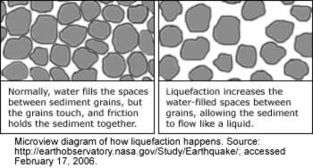
                                                             ii.      Landslides
Landslides happen when the ground starts shaking. They are usually more damaging than earthquakes because they can cause lots of property damage and death. Varieties of resources can also be ruined because of a landslide! For instance water supplies, fisheries,sewage disposal systems, forests  and roadways can be ruined. This would also have a negative impact on the economy to repair and pay for all the damages.
                                                            iii.      Tsunami
Another dangerous effect of an earthquake is a tsunami. They are giant waves that can cause floods and can become very tall in height. These deadly waves strike a great distance from the epicentre. They often result from sub sea faulting of the ocean floor which sends seismic shocks through the water. They can cause lots of property and environmental damage. Also peoples lives are in danger because of tsunamis.
                                                          iv.      Flooding
Flooding occur from many various reasons. Such as broken water  pipes, or earthquake-generated tsunamis. Flooding is very dangerous since it can damage buildings, sweep away cars and drown people.  It negatively impacts the area where the earthquake already has done so much damage.

b.     Consider the impact on the following areas. Use as much detail as possible and specific examples in your explanations.
                                                               i.      Social Impact (Impact on humans) (5 marks)
Earthquakes can have huge social impact on humans. Whether the earthquake be short or long term impacts. The short term impacts include people being  killed, homes being destroyed, transportation links to be disrupted, water pipes bursting and water supplies to be contaminated with toxic chemicals. Long term impacts may involve disease, people having to rebuild their house and building the city to what it use to be.
                                                             ii.      Economic Impact (Money) (5 marks)
Earthquakes can cause economic impacts. Short term impacts may be small shops and business places being destroyed and damage to transport links (bridges) which could cause trading to become difficult. Long term impacts involve the cost of rebuilding the city which can be very expensive! Investment in the area may be focused on repairing damages which can be even more costly and lots of income or major insurance losses due to the earthquake.
                                                            iii.      Impact on Infrastructure (Buildings, bridges, tunnels, roads, airports, water reservoirs, skytrain) (10 marks)
Earthquakes negatively impact the infrastructure as well. It can cause large buildings to collapse which can result in the wreckage of many urbanized areas. Bridges, skytrains and roads would be destroyed and blocked, which would make it an obstacle for goods, ideas and for people to move around. It would especially make it difficult for fire-fighters, police officers, and many more public service workers to help if roads were blocked. Water reservoirs would become contaminated and not drinkable to the public. Airports would get destroyed resulting in planes to not be able to enter or leave the terminal. Public places would be ruined such as schools and hospitals. Less people would get the education they need which could help the public learn what to do in earthquakes. If hospitals were destroyed, it would be difficult to treat injured people and save lives of the innocent people.

4)     Describe some of the ways that communities in Metro Vancouver are preparing for the impending earthquake. Think about the things in part 3) a. and b. in your explanation. (8 marks)
Some ways communicates in Vancouver are preparing for the big bam!
- Having first aid kids ready at home
-Storing canned gods and fresh water in their homes, workplace and cars
-Planning a safe meeting spot for families when the earthquake will occur 
-Having shelves and various other objects securely screwed into the wall
-Putting heavy items away from top shelves to help save from damages
-Stocking up on flashlights and batter packs
-Creating more secure buildings and fixing hanging lighting fixtures
-Hanging items like mirrors away from siting areas 
-putting flammable liquids and bottles further from high shelves or far from people for safety reasons
-educating the public on how to survive an earthquake

Some links below explain this case study!

http://www.ctvnews.ca/pacific-northwest-at-risk-for-a-mega-earthquake-1.516808

http://www.cbc.ca/player/News/TV%20Shows/The%20National/ID/1511465234/

https://www.youtube.com/watch?v=Bq1VHnq0Yvk

Plate Tectonics in Your country

Plate Tectonics in Your country

*If you do not have a plate boundary in or near your country explain what is happening off the coast of BC….Hawaii, Central USA, Eastern USA, South Africa…There may be a few others

You are going to look at how plate tectonics is impacting your country.

1) You will need to find a map of the plates of the world? What plate is your country located on? Is it split over two plates? Is it located near a plate boundary? If yes…Which one? Include at least one relevant picture in this section.Geology indonesia map.jpg
The tectonics of Indonesia can be very confusing as they are quite complex.  There is a meeting point of several tectonic plates. Indonesia is located between two continental plates which are the the Eurasian Plate and Australian Plate. It is also between two oceanic plates which are the the Philippine Sea Plate and Pacific Plate. The subduction of the Indian oceanic plate beneath the Eurasian continental plate formed the volcanic arc in western Indonesia! That area is one of the most seismically active areas on the planet with a long history of powerful eruptions and earthquakes. This chain of active volcanoes formed SumatraJavaBali, and Nusa Tenggara islands,

Because there are so many plates near Indonesia i decided to do a bit of research on the Eurasian plate. The Eurasian Plate is a tectonic plate which includes most of the continent of Asia and Europe.The eastern side is a boundary is the Eurasian and  the north  is the North American plate. Then there is a boundary with the Philippine Sea Plate to the south of it.The southerly side is a boundary with the African Plate to the west. This westerly side is a divergent boundary with the North American Plate. In 1973 the volcano of Icelandic island was caused by the north american plate and Eurasian plate moving apart. Thus the reason there is a result of a divergent plate boundary force.
There can be many hazards associated with diverging plates. When plates move apart magma rises which creates many small earthquakes and volcanoes. Usually the earthquake is underground in water so many people don't notice (take an example of Indonesia). Yet in some places its on land and can be very scary! Mostly a concern to Icelanders because the mid ocean ridge actually comes to the surface there!

2) Research a little bit about the plate that your country is located on. In which direction it is moving? How quickly is it moving? What plates is it currently interating with? In which way (converging, diverging, transform)?


3) What are the features that form as a result of the plate boundaries and plate movement occuring in or near your country? (ie if you have oceanic-oceanic convergence what forms? If it is divergent what forms? Subduction?)
The Eurasian plate and its partner the American plate are divergent boundaries. How did it come to be? When two plates are moving away from each other it is a divergent plate boundary. Both plates were driven apart and now are divergent plate boundary! Along these boundaries, magma rises from deep within the Earth and erupts to form new crust on the lithosphere( which caused the Icelandic Island)!

4) Describe the associated hazards that occur as a result of the plate boundaries. Ie. Earthquakes/Volcanoes.


5) Research folds and faults within your country…. …Find examples and pictures.
The Indonesian island of Sumatra is located in a highly seismic area. Sumatra has a large strike slip fault! It is known as the Great Sumatran Fault. This fault runs along the entire island! This fault zone accommodates most of the strike-slip motion associated with the convergence between the Indo-Australian and Eurasian plates. 


Energy Assignment Part 3

You are now going to go back to the 3 energy types that you researched in Part 1 of this assignment. You are going to rank them based on their potential to be implemented in your country.


Based on the potential to be implanted in my state i would rank the energies in this order for Indonesia:
-Coal energy

-Wind energy
-Solar energy


I ranked Coal energy as their first because it is already being used in the country. The country is a developing country which needs help financially and coal seems to be the best option for them as of now. The coal mining is affordable for Indonesia because it is not as expensive as it is to make solar panels. The size of Indonesia is large enough for coal mining to take place. However research shows each mining area is good for Indonesia for about 80 years. So in the short run running out of coal is not a huge issue to Indonesians. Indonesia is one of the top ten coal producers in 2013. They stand at fourth place! The government and the community  also help out in coal mining. Coal mining opens up many jobs for the public which allows them to earn money for themselves and a profit is gained for the government.
Top Ten Coal Producers in 2013:
 1. China     1840.0 Mt 6. Russia     165.1 Mt
 2. USA      500.5 Mt  7. South Africa
     144.7 Mt
 3. Australia      269.1 Mt  8. Kazakhstan      58.4 Mt
 4. Indonesia      258.9 Mt 8. Poland      57.6 Mt
 5. India      228.8 Mt10. Colombia      55.6 Mt


I ranked wind energy second due to Indonesia and its finical budgeting. Although solar panels seem like a better idea it is still a little more expensive to build. Indonesians cant afford to pay for the luxury of that. Thats why wind energy comes into play! In certain areas of Indonesia there already is wind energy to help save the environment.The main wind energy potential areas are located in East and West Nusa Tenggara. However the climate may become an issue if wind energy was put in place everywhere. Wind energy requires its turbines to have wind. The main variable of Indonesians climate is not temperature or air pressure but rainfall! With rain it might to be a good idea to use wind energy. I did not rank this first because wind is unpredictable so the people int eh country should not be to dependent on wind energy. The government has recently started using this type of energy to help the environment and have the wind turbines installed to use for electricity in Indonesia.

I ranked Solar energy at third! Although it is  a better option out of the three it is quite expensive to build and manufacture. I think it would be a good idea to invest in because in the beginning you pay the big hefty price but afterwards the costs are less. How much does it really cost to use the suns rays? If you add up the amount of money used to mine, transport and manufacture coal it is probably the same as solar energy maybe even a little more costly in the long run! The geography for my state is actually perfect for solar energy. Indonesia is in the middle of earth (near the equator) so the sun is always shining on the country! The size of Indonesia is pretty good in the sense of covering range for the panels. The government has set up small areas with solar panels to also help save the environment. However most of the time the people have to but it on their own to light up their house or to bring in heat in a safer way. Which probably is the reason why mostly everyone rely on coal!

Energy Assignment Part 2

In this portion of the assignment you are going to research the type of energy currently used in your country. You will likely find that there are multiple types used (and you can mention this) but please try to focus on the primary type used. Explain how this is used, the cost, the impact, etc. It may be one of the three that you researched yesterday or may not be….It doesn't matter.

/10

Primary energy used:
In Indonesia the primary type of energy used is coal.Indonesia is well supplied with medium and low quality thermal coal. At current rates of production, Indonesia's coal reserves are expected to last for over 80 years. Coal is a combustible black or dark brown rock that is mainly in underground deposits and widely is used as fuel.

How is it used?
The most significant uses of coal are in electricity generation, steel production, cement manufacturing and as a liquid fuel.Different types of coal have different uses. Steam coal - also known as thermal coal  is mainly used in power generation. Coking coal  also known as metallurgical coal is mainly used in steel production. Other important users of coal include alumina refineries, paper manufacturers, and the chemical and pharmaceutical industries. Several chemical products can be produced from the by-products of coal. 

How is Coal Converted to Electricity?
Steam Coal is first milled to a fine powder, which increases the surface area and allows it to burn more quickly. In these pulverised coal combustion systems, the powdered coal is blown into the combustion chamber of a boiler where it is burnt at high temperature. The hot gases and heat energy produced converts water,  in tubes lining the boiler, into steam.

Costs?
Coal is much more inexpensive however in the long run costs us the environment and our health. Covenional coal is around $94 per meawatthour! Compare this price to solar which is $160 per megawatthour.energy costs from EIA

Impacts:
The environmental impact is a negative with the coal industry. Such issues include land usewaste managementwater and air pollution, which is all caused by the mining of coal,  There are severe health effects caused by burning coal. According to the reports issued by the World Health Organization in 2008 state coal particulates pollution are estimated to shorten approximately 1,000,000 lives annually worldwide.Surface mining of coal causes direct and indirect damage to wildlife. The impact on wildlife begins primarily from disturbing, removing and redistributing the land surface. Some impacts are short-term but some can be long term! The combustion of coal is one of the largest man made contributor to carbon dioxide in the air! Electric generation using coal burning produces around twice the greenhouse gases compared to the generation of natural gas. Over all the coal may be cheap and easy to use however it is impacting the live hood around it severely in the long run!


Energy Assignment Part 1

You are going to start this assignment by researching 3 of the following types of energy production options. Please research ones that interest you AND NOT just the ones that your friends choose. I will be checking when I mark to ensure that natural social groupings have no researched the exact same things. 
For EACH of the energy types that you research you should look at the pros and cons, how we use it, the benefits, drawbacks etc. Make sure that you are familiar with how they work. 

From the following list choose THREE: 
-Coal
-Nuclear
-Solar
-Tidal
-Wind
-Hydrothermal
-Geothermal

Coal:

Coal is a fossil fuel which is used around the world to produce electricity. It is a black sedimentary rock. Somethings it can be brown is very flammable. It is mostly made out of organic carbon and is a primary source for energy. It is mainly used to produce heat or electricity. Back in the days it was frequently used to heat up homes and power factories and trains. Since the 2000's coal consumption as risen up a lot than any other fuel globally. Around 6 billion tonnes of coal were used world wide in 2014! Thats how important coal is in modern society.

Pros for coal:
-inexpensive
-supply is more in industrialized cities/countries
-good utilization
-cheaper than gas (better to invest in financially)
-continuous power
-can change to a liquid state
-can turn into low carbon 

Cons for coal:
-not a renewable source
-has a large contribution to global warming
-has different levels for radiation
-emits methane (a lot of it)
-bad for environment around it
-has carbon dioxide in it
-impacts human health negatively
-burning coal emits mercury
-increases the rate of asthma and cancer in lungs

Solar:

Solar energy comes from the suns rays which is converted into electricity for various products. For instance light bulbs to light up a  house! This type of energy can be used in heating pools, water, homes and even for ventilation. It can heat up things that coal can heat up! Many people use solar energy lights on their driveway. So how does it work? There are panels called solar cells that convert sunlight into electricity. Using the energy of photons it creates current with the panel. A photon is created in the sun by the fusion of atoms.

Pros:
-Can replace certain products that need coal
-Using it is cost efficient
-Renewable source
-High efficiency
-Doesn't pollute the atmosphere
-saleable of at least 100MW level

Cons:
-low energy
-a little more expensive than the solar PV
-have to set it up in a proper location
-need to have proper upgraded technology to create
-to create the panel is super expensive
-Needs a lot of space
-does not look pretty in backyards
-manufacturing may cause pollution
-people still would rather buy gas (its cheaper)

Wind:

This type of energy also can be used for almost anything.. It can power boats, batteries and be used for electricity! In the olden days instead of wind turbines there was wind mills. Wind turbines convert energy in the wind and change it into mechanical power. This power can be used for pumping water or giving light in a house. Wind turbines can use generators to turn the wind energy into electricity. Which leads the house having light.

Pros of wind energy:
-also renewable
-a sustainable option
-no land is being drilled to collect it (saves environment)
-power is free
-cost is lower
-can be used almost anywhere

Cons of wind energy:
-have to rely on government as wind power may not be cheap
-turbines make a lot of noise
-birds have casualties from the propellers
-wind is not always blowing in the sky
-wind is inconsistent and unpredictable


Impact of Climate Change

Using SPECIFIC examples from your country, list the impacts that Climate Change will/ is having on it. You should organize your information based on the impact on the 4 spheres of the Environments. You must include AT least 4 pictures on your assignment. 1 mark will be given for every example up to a total of 30.

These are the following impacts that impact Indonesia:
Biosphere:
the regions of the surface, atmosphere, and hydrosphere of the earth:
- Negative impacts on human health (cholera)
-Negative impact on human lives (cause death)
-Destruction of certain plants
-Destruction of farmland crops
-Loss of aquaculture
-Loss of other living organisms(such as animals)
-Marine migration
-Human movement (away from the country)
-Fishing would decline (loss of profit)
-Destruction to trees and rainforests
-Destruction of topsoil
-Can start desertification

Atmosphere:
the envelope of gases surrounding the earth or another planet:
-Warmer climate in the atmosphere because of the rise in temperature
-More pollution in the atmosphere
-Trade winds decrease
-More carbon dioxide in the air than oxygen

Lithosphere:
the rigid outer part of the earth, consisting of the crust and upper mantle:
-Loss of land
-Prone to more droughts
-Coastal areas are destroyed due to erosion
-Beaches can be destroyed
-Destruction to roads mountains and the soil

Hydrosphere:
all the waters on the earth's surface, such as lakes and seas, and sometimes including water over the earth's surface, such as clouds:
-Contamination in drinking water
-Water bodies could decrease in size
-Ocean acidification
-Coastal floodings may occur
-Oceans are more warmer than cool
-Sea level rises
-Less fresh water(could get contaminated) for living organismis
-Water around that area is polluted